34. Port Charcot, Booth Island |
||||||||||||

|
||||||||||||
|---|---|---|---|---|---|---|---|---|---|---|---|---|
|
||||||||||||
|
||||||||||||
| Description | ||||||||||||
| TOPOGRAPHY | ||||||||||||
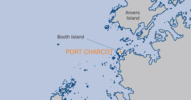
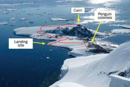
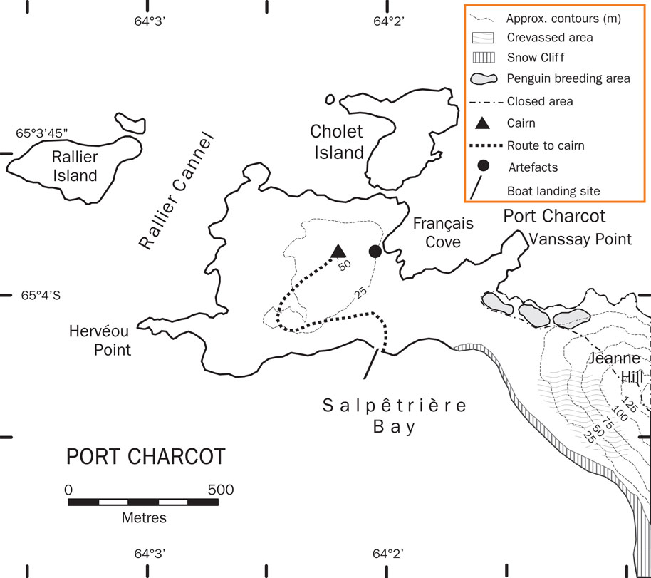
| Port Charcot is a 2.4km wide bay at the north of Booth Island, an 8km long Y-shaped island forming the western side of the Lemaire Channel. This bay lies on the north-western arm of the “Y” shore of Booth Island. From the southern beach of the NW arm (Salpêtrière Bay) the site rises through a gentle slope leading to the north to a 50m hill where remains of the Charcot’s expedition can be found. On the northern shore there is a small cobbled bay, Français Cove, on the north shore sheltered by two small offshore rocky islets and a series of rocky outcrops surround the bay. | ||||||||||||
| FAUNA | ||||||||||||
| Confirmed breeders: Adélie penguin, Antarctic tern, Blue-eyed shag, chinstrap Penguin, Gentoo penguin, Kelp gull, Skua, Snowy sheathbill, South Polar Skua, Wilson’s storm petrel. | ||||||||||||
| Regularly haul out: Antarctic fur seal, Weddell seal. | ||||||||||||
| Also present: Leopard seal. | ||||||||||||
| FLORA | ||||||||||||
| Snow algae may be extensive in late summer. Biota noted include: Antarctic hairgrass (Deschampsia antarctica), various moss species, algae including Prasiola crispa and lichens including Xanthoria spp., Caloplaca spp. and Verrucaria spp. | ||||||||||||
| OTHER | ||||||||||||
| The location is the overwintering site of the French Antarctic Expedition, 1903-1905 onboard the Français under the command of Jean-Baptiste Charcot. Remains from the expedition are still visible in the form of a cairn with a wooden pillar (designated HSM 28), the stone built magnetic hut, the wreck of a tender and other artefacts. | ||||||||||||
| Visitor Impact | ||||||||||||
| KNOWN IMPACTS | ||||||||||||
| None known. | ||||||||||||
| POTENTIAL IMPACTS | ||||||||||||
| Disturbance of wildlife. Disturbance of historic artefacts. | ||||||||||||
| Landing Requirements | ||||||||||||
| SHIPS* | ||||||||||||
|
Max pax on board: 500
Ships at a time: 1 Comments: Maximum 2 ships per day (midnight to midnight), of which no more than 1 can carry over 200 passengers. * A ship is defined as a vessel which carries more than 12 passengers. |
||||||||||||
| VISITORS | ||||||||||||
|
Maximum number of visitors at any time, exclusive of expedition guides and leaders: 100 |
||||||||||||
| Visitor Area | ||||||||||||
| LANDING AREA | ||||||||||||
| Primary Landing: Salpêtrière Bay, from which it is a short walk across the saddle to Port Charcot. Landings can also be made into the small cobbled bay of Français Cove, but the bay is shallow and rocky at low tide. | ||||||||||||
| CLOSED AREA | ||||||||||||
| The steep rocky area on the north side of Jeanne Hill. The south side of Jeanne Hill is not closed but is crevassed and dangerous. | ||||||||||||
| GUIDED WALKING AREA | ||||||||||||
| It is recommended that walks to the cairn are led by guides, to avoid steep, slippery slopes below. | ||||||||||||
| FREE ROAMING AREA | ||||||||||||
| Visitors may roam freely in the area between the primary landing site in Salpêtrière Bay northwards across the saddle to Port Charcot and east towards the penguin colonies at the foot of Jeanne Hill, taking into account the cautionary notes below. | ||||||||||||
| Visitor code of conduct | ||||||||||||
| BEHAVIOUR ASHORE | ||||||||||||
|
||||||||||||
| CAUTIONARY NOTES | ||||||||||||
|
The sea-area in the vicinity of Port Charcot is poorly surveyed. Care needs to be taken in the vicinity of historic artefacts (see map), some of which may be partially hidden by snow. The permanent ice slopes are crevassed and dangerous. These areas should only be accessed by those with suitable alpine experience and training, and using suitable equipment (e.g. roped access). Caution must be used when walking close to the snow overhangs east of the Salpêtrière Bay landing site, which may be unstable. |
||||||||||||

|
||||||||||||
|
||||||||||||
|
||||||||||||
|
|
Please note that ATCM / CEP circulars are available only to specific contact points.
Please contact your Party Contact Administrator, to confirm if you have privileges to access this section.
To access this section you must log in using your personal Username/Email and password as registered in the AT Contacts Database.
To access this section you must log in using your personal Username/Email and password as registered in the AT Contacts Database.
If you are not registered, please request your party’s Contact Administrator to assign your credentials or contact the Secretariat for assistance.