21. Cape Royds |
||||||||||

|
||||||||||
|---|---|---|---|---|---|---|---|---|---|---|
|
||||||||||
|
||||||||||
| Description | ||||||||||
| TOPOGRAPHY | ||||||||||
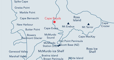
| Cape Royds is a strip of low-lying volcanic ice free land on the western coast of Ross Island (Map 1). Mt Erebus (3795 m), an active volcano, lies ~24 km east of Cape Royds. | ||||||||||
| FAUNA | ||||||||||
| Confirmed breeders: Adélie penguin, South Polar Skua. | ||||||||||
| Regularly haul out: Weddell seal. | ||||||||||
| Seen near-shore: Antarctic petrel, Emperor penguin, Leopard seal, Snow petrel. | ||||||||||
| A polynya (open water) commonly present off Cape Royds supports a rich and diverse marine fauna. | ||||||||||
| FLORA | ||||||||||
|
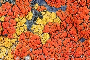
The southernmost recorded green snow algae in the Ross Sea region occur near the penguin colony at Cape Royds. Crustose lichens, common only in a few sites in the region have been recorded in the area. |
||||||||||
| OTHER | ||||||||||
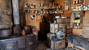
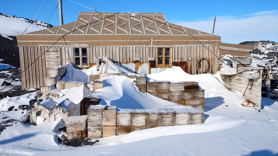
| Cape Royds is one of the principal areas of early human activity in Antarctica. The hut built by Shackleton’s Nimrod Expedition 1907-09 remains at Cape Royds as an important symbol of the heroic era of Antarctic exploration and has been designated Historic Site and Monument (HSM) No. 15. Numerous artefacts remain within the hut and in the surrounding area. Cape Royds hosts the most southerly established Adélie penguin (Pygoscelis adeliae) colony. | ||||||||||
| Visitor Impact | ||||||||||
| KNOWN IMPACTS | ||||||||||
| Disturbance to the penguins and skuas, disturbance to historic artefacts, cumulative effects of human presence in and around the hut, tracking and ground compaction. | ||||||||||
| POTENTIAL IMPACTS | ||||||||||
| Disturbance to sensitive flora and fauna communities, damage to hut and associated artefacts, fire, importation of non-native species, litter, disturbance to research, tracking and ground compaction, noise. | ||||||||||
| Landing Requirements | ||||||||||
| SHIPS* | ||||||||||
|
Comments: No current limit on ships, although visitor numbers are subject to the limits set below. * A ship is defined as a vessel that carries more than 12 passengers. |
||||||||||
| VISITORS | ||||||||||
|
Comments: Entry into ASPAs No. 157 and No. 121 is prohibited except in accordance with a permit which must be carried on site. Permits to enter ASPA No. 121 will not be given for recreational visits; visitors to ASPA No. 157 must avoid ASPA No. 121, including the marine area. All visitors to ASPA No. 157 must be accompanied by a trained guide. Consult the ASPA Management Plans and permits for further information. The historic hut is locked and a key must be obtained as part of the permitting process. • Annual max. number of visitors into ASPA No. 157 (including guides): 2000 people. • Max. number of people in ASPA No. 157 at any one time (including guides and those within the hut): 40 people. • Max. number of people inside the hut at any one time (including guides): 8 people. |
||||||||||
| Visitor Area | ||||||||||
| LANDING AREA | ||||||||||
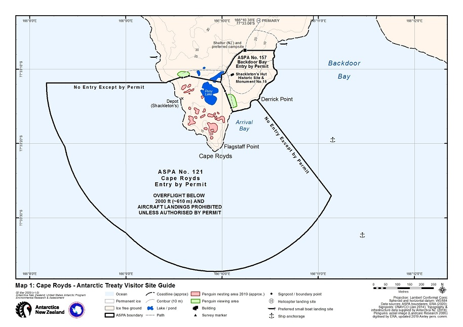
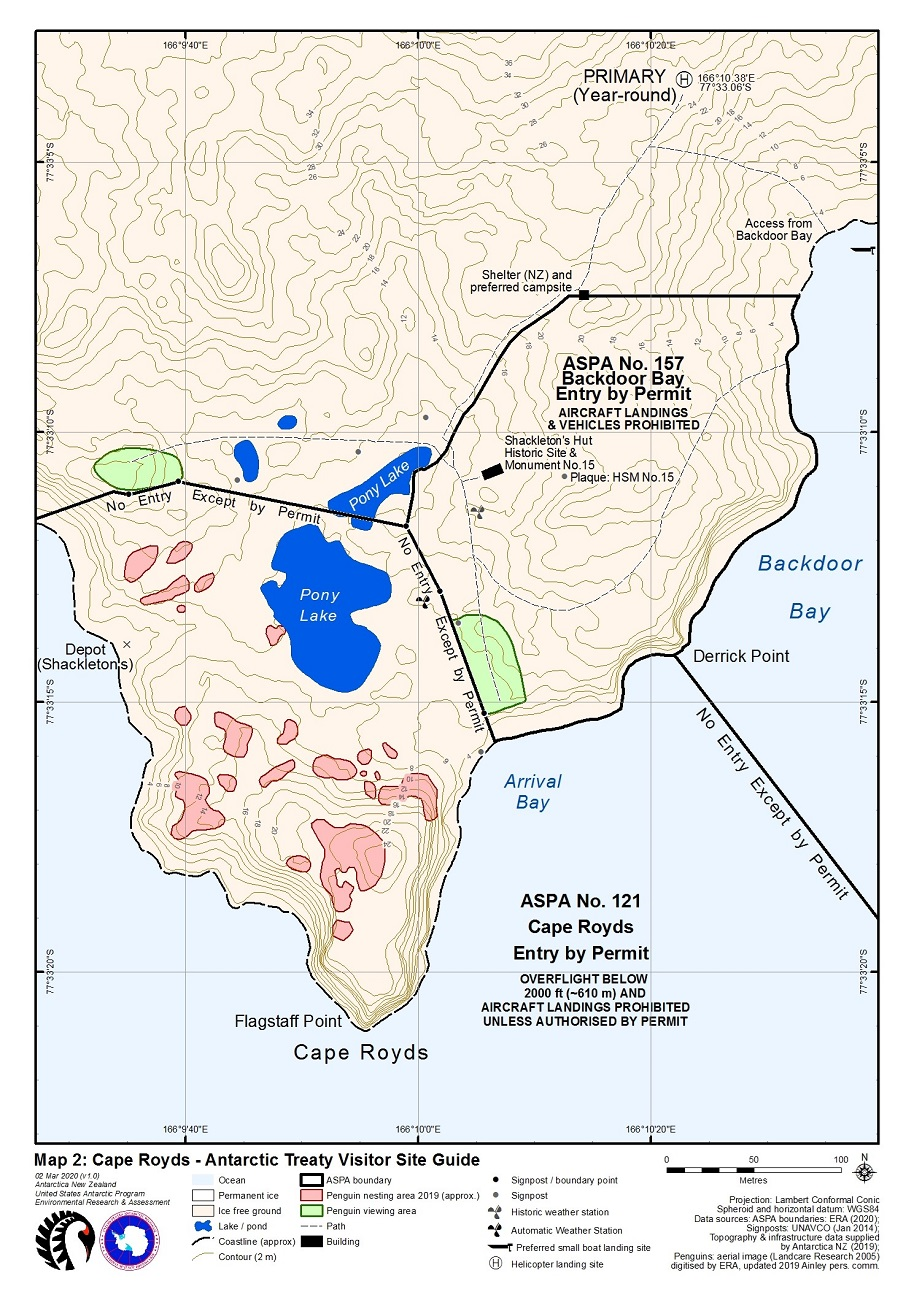
| Access by foot or small boat should be made from Backdoor Bay (taking care to avoid the marine extent of ASPA No. 121) following the walking route shown in Map 2. Small boat access may also be made to a bay on the western coast of Cape Royds ~100 m north of the boundary of ASPA No. 121 (Map 1). Helicopter landings and overflight below 610 m (~2000 ft) Above Ground Level (AGL) within ASPAs No. 121 and No. 157 are prohibited. Helicopters should land at the Primary landing site (7733.06'S 16610.38'E, Maps 1 & 2), 250m northeast of Shackleton’s hut. | ||||||||||
| CLOSED AREA | ||||||||||
|
• ASPAs are closed except to permit holders. Permit holders must be careful to adhere to the requirements and visitor numbers specified in the management plans. • ASPA No. 121 is closed to recreational / tourist visits. • Refuge huts for science / conservation support are closed to visitors. |
||||||||||
| GUIDED WALKING AREA | ||||||||||
| Visitors entering ASPA No. 157 and the hut must be accompanied by a guide. Particular care should be taken when walking along the preferred routes to the areas suitable for viewing penguins, to the helicopter landing site and to Backdoor Bay, to avoid historic artefacts still present on the ground, vegetation and skua nesting sites, which may be difficult to see. Visitors must stay on the preferred walking routes. | ||||||||||
| FREE ROAMING AREA | ||||||||||
| Visitors may roam freely under supervision outside of the boundaries of ASPAs No. 157 and No. 121. The Visitor Code of Conduct (below) shall be followed at all times. In particular, care should be exercised to avoid nesting skuas, any vegetation, and any scientific installations or camps in the area. | ||||||||||
| Visitor code of conduct | ||||||||||
| BEHAVIOUR ASHORE | ||||||||||
|
||||||||||
| CAUTIONARY NOTES | ||||||||||
|
||||||||||
|
||||||||||
| Fig 1: Shackleton’s hut, Cape Royds. Photo A. Kerr, Antarctica NZ (23 Oct 2016). | ||||||||||
|
||||||||||
|
||||||||||
|
Please note that ATCM / CEP circulars are available only to specific contact points.
Please contact your Party Contact Administrator, to confirm if you have privileges to access this section.
To access this section you must log in using your personal Username/Email and password as registered in the AT Contacts Database.
To access this section you must log in using your personal Username/Email and password as registered in the AT Contacts Database.
If you are not registered, please request your party’s Contact Administrator to assign your credentials or contact the Secretariat for assistance.