46. Cape Bird, Ross Island |
|||||||

|
|||||||
|---|---|---|---|---|---|---|---|
|
|||||||
|
|||||||
| Description | |||||||
| TOPOGRAPHY | |||||||
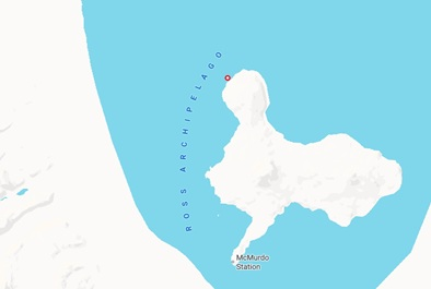
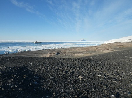
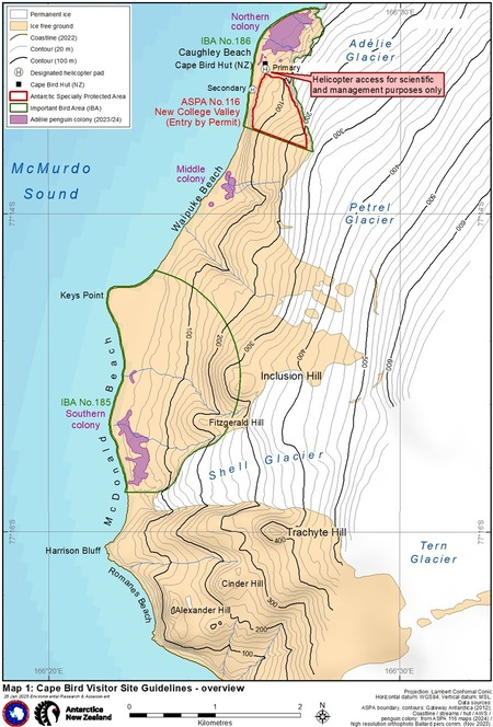
| Cape Bird lies at the northern extremity of Mount Bird (1,800 m), an inactive volcanic cone on Ross Island. An ice-free area on the lower western slopes of Mount Bird hosts the second largest Adélie penguin colony on Ross Island. This part of the coastline consists of hilly terrain of basaltic geology, glacial moraines and a series of broad, relatively flat, areas of beach sediments. The penguin colony occupies the lower slopes in three distinct groups: the northern, middle and southern colonies (Map 1). The northern colony above Caughley Beach is the largest of the three with ~45,000 breeding pairs (Figure 1). | |||||||
| FAUNA | |||||||
| Confirmed breeders: Adélie penguin, South Polar Skua. | |||||||
| Regularly haul out: Weddell seal. | |||||||
| Also present: Antarctic petrel, Emperor penguin, Leopard seal, Snow petrel. | |||||||
|
Snow petrels (Pagodroma nivea), Antarctic petrels (Thalassoica antarctica), Emperor penguins (Aptenodytes forsteri) and Leopard seals (Hydrurga leptonyx) are commonly observed in the area, although are not known to breed at this location. |
|||||||
| FLORA | |||||||
| Some of the richest stands of moss in the southern Ross Sea and associated microflora (including algae, cyanobacterial communities and lichen encrustations on moribund moss) colonise slopes above Caughley Beach. In recognition of these values, the area of New College Valley was designated an Antarctic Specially Protected Area (ASPA No. 116). | |||||||
| OTHER | |||||||
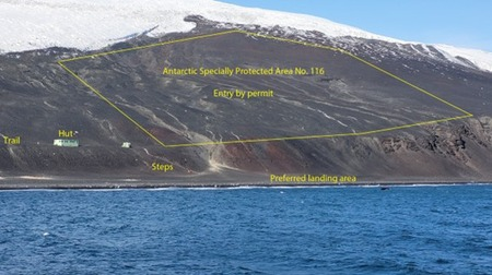
| New Zealand’s Cape Bird field hut (Figure 2) is situated on the hill above Caughley Beach near the ASPA No.116 boundary. The hut was constructed in 1991, replacing the original built in 1966. An Automatic Weather Station (AWS) is set up ~100 m northeast of the Cape Bird field hut. | |||||||
| Visitor Impact | |||||||
| KNOWN IMPACTS | |||||||
| Wildlife disturbance from human activities, cumulative effects of human presence around the field hut, tracking and ground disturbance, including the erosion of a trail down the hill from the hut. | |||||||
| POTENTIAL IMPACTS | |||||||
| Disturbance to wildlife, trampling of vegetation, erosion of footpaths, tracking, ground compaction, importation of non-native species or disease, litter pollution, disturbance or damage to research, research equipment or the field hut, and potential fuel spills from small boat operations. | |||||||
| Landing Requirements | |||||||
| SHIPS* | |||||||
|
Max pax on board: 200
Ships at a time: 1 Comments: Ships carrying 200 or fewer passengers. One ship at a time. * A ship is defined as a vessel that carries more than 12 passengers. |
|||||||
| AIRCRAFT | |||||||
| The designated helicopter landing sites at Cape Bird are for support of scientific research and management only. | |||||||
| VISITORS | |||||||
|
Maximum number of visitors at any time, exclusive of expedition guides and leaders: 100 Visitors per guide: 15 Comments: No more than 100 visitors ashore at any time, exclusive of expedition guides and leaders. Visitors per guide: 15. |
|||||||
| Visitor Area | |||||||
| LANDING AREA | |||||||
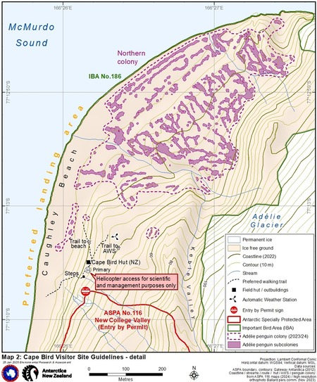
| Cape Bird may be accessed by small boat. The preferred landing area for small boats is along Caughley Beach below the field hut (Map 2). However, in difficult ice, swell or wind conditions, landings may also take place towards the northern end of the northern colony. Landings may be made on more southerly beaches according to conditions, with the small embayment north of Keys Point potentially offering more shelter from swell (Map 1). Landings where penguins are transiting between land and sea should be avoided. | |||||||
| CLOSED AREA | |||||||
|
Entry into ASPA No. 116 is prohibited without a permit. Entry for tourism purposes is prohibited. The Cape Bird field hut, stores hut and toilet located on the hill above Caughley Beach are closed to visitors. |
|||||||
| GUIDED WALKING AREA | |||||||
| Visits to the hut should only be made by following the preferred walking trail (Map 2). This trail follows steps up to the hut (Figure 2) and an established trail north of the hut extends ~100 m back down to the beach. Visitors may visit the AWS, but this and any other scientific equipment should not be disturbed. | |||||||
| FREE ROAMING AREA | |||||||
| Visitors may roam freely along Caughley Beach under close supervision. Care should be taken when viewing penguins to avoid disturbance to penguin nests, skua nesting sites or vegetation. After Adélie chicks have fledged and adults have returned to sea (February), visitors may under close supervision roam further onto the area where nesting sites were formerly occupied. | |||||||
| Visitor code of conduct | |||||||
| BEHAVIOUR ASHORE | |||||||
|
|||||||
| CAUTIONARY NOTES | |||||||
|
|||||||

|
|||||||
|
|||||||
| Figure 1. View of northern colony from the hill near Cape Bird field hut, including the cruise ship, Beaufort Island and Adélie Glacier ice cliffs (Source: Jenny Ridgen, 22/23). | |||||||
|
|||||||
| Figure 2. View of Caughley Beach from tour ship, including ASPA 116, Cape Bird field hut, steps to hut, Adélie Glacier and the trailhead that leads back down the hill to Caughley Beach (Source: Cornelia Vervoorn, 23/24). | |||||||
|
|
|||||||
|
|
|||||||
|
|||||||
|
Please note that ATCM / CEP circulars are available only to specific contact points.
Please contact your Party Contact Administrator, to confirm if you have privileges to access this section.
To access this section you must log in using your personal Username/Email and password as registered in the AT Contacts Database.
To access this section you must log in using your personal Username/Email and password as registered in the AT Contacts Database.
If you are not registered, please request your party’s Contact Administrator to assign your credentials or contact the Secretariat for assistance.