17. Whalers Bay |
||||||||||||

|
||||||||||||
|---|---|---|---|---|---|---|---|---|---|---|---|---|
|
||||||||||||
|
||||||||||||
| Description | ||||||||||||
| TOPOGRAPHY | ||||||||||||
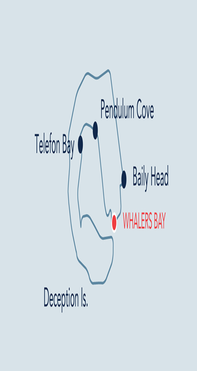
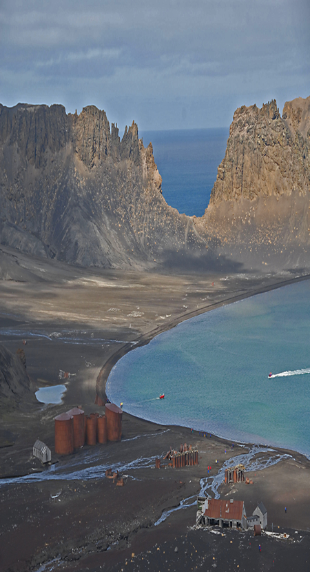
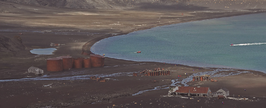
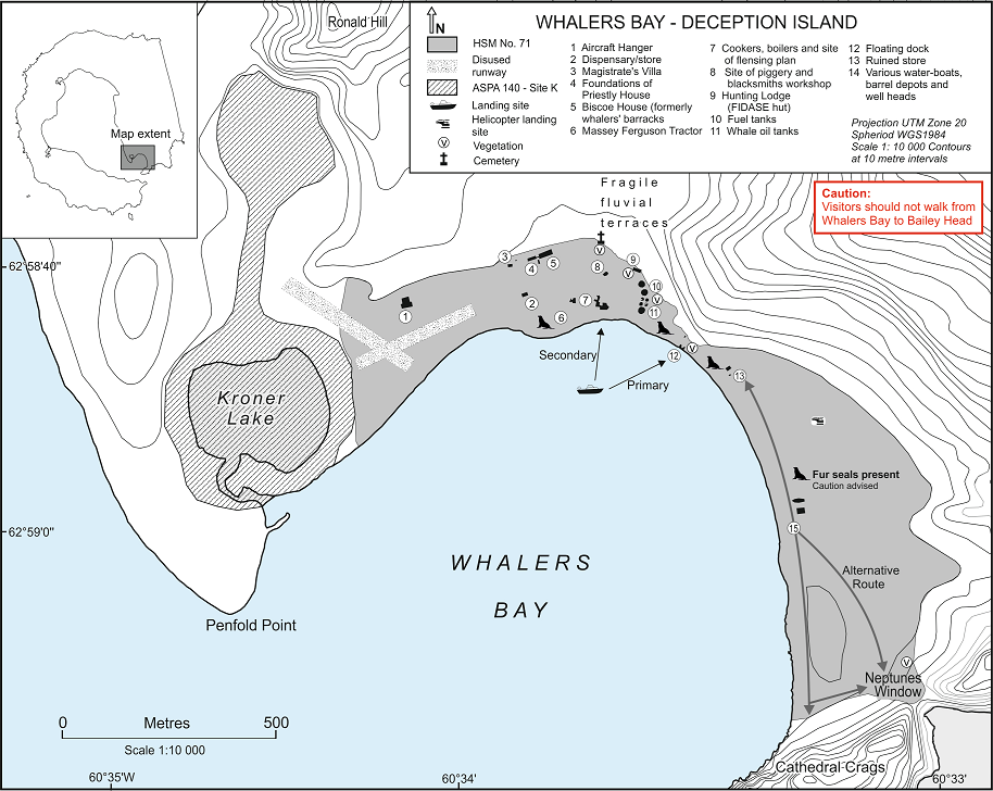
| Whalers Bay is a small harbour located immediately to the northeast after passing through Neptune’s Bellows. The Whalers Bay site includes a semi-circular, gently sloping ash beach, which is approximately 2km in length and stretches from Penfold Point in the northwest to Cathedral Crags in the southeast. Kroner Lake, a geo-thermally heated lagoon, is located on the western side of the bay. Ronald Hill (103m) is located 800m north of the lagoon, whilst steep glacier cliffs with dark grey pyroclastic layers rise immediately to the northwest. A collapse of Cathedral Crags on the south-eastern side of Whalers Bay is known as Neptune’s Window. Of particular importance are the low fluvial terraces behind the site of the whaling station and remains of the lahar (mud slide) which formed as a result of an eruption in 1969. | ||||||||||||
| FAUNA | ||||||||||||
| Confirmed breeders: Antarctic tern, Cape petrel, Kelp gull, Skua, Wilson’s storm petrel. | ||||||||||||
| Hauled out: Crabeater Seal, Fur seal, Weddell seal. | ||||||||||||
| Offshore: Leopard seal. | ||||||||||||
| Resting: Blue-eyed shag, chinstrap Penguin, Gentoo penguin, Snowy sheathbill. | ||||||||||||
| FLORA | ||||||||||||
|
Geo-thermally active scoria outcrops to the east of the whaling station support moss and lichen, which also grow on the timber, iron and brick structures and on the cliffs and massive boulders at Cathedral Crags and Neptunes Window. Rare and important species may also be present. Deschampsia antarctica and lichen species including Usnea spp., Xanthoria spp., and Caloplaca spp. are present in the Cathedral Crags area. |
||||||||||||
| OTHER | ||||||||||||
|
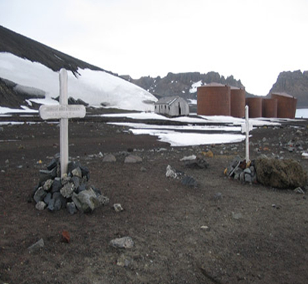
The buildings, structures and other artefacts on the shore of Whalers Bay, which date from the period 1906-1931, represent the most significant whaling remains in the Antarctic. Other buildings, structures and artefacts of the British ‘Base B’ represent an important aspect of the scientific and aerial mapping history of the area (1944- 1969). The site is designated as Historic Site and Monument No. 71. |
||||||||||||
| Visitor Impact | ||||||||||||
| KNOWN IMPACTS | ||||||||||||
|
Graffiti on historic structures. Removal of historic artefacts. Erosion of footpaths en route to Neptunes Window. There is known erosion and trampling of vegetation on the path between Baily Head and Whalers Bay. |
||||||||||||
| POTENTIAL IMPACTS | ||||||||||||
|
Damage to or removal of historic artefacts. Trampling of vegetation. Erosion of further paths. Fire. Damage to beach area due to ship operations (anchoring, release of pollutants, maritime accidents, etc.). |
||||||||||||
| Landing Requirements | ||||||||||||
| SHIPS* | ||||||||||||
|
Max pax on board: 500
Ships at a time: 1 Comments: Maximum 3 ships per day (midnight to midnight), of which no more than 2 can carry over 200 passengers. * A ship is defined as a vessel which carries more than 12 passengers. |
||||||||||||
| VISITORS | ||||||||||||
|
Maximum number of visitors at any time, exclusive of expedition guides and leaders: 100 Visitors per guide: 20 Comments: Guides should be positioned at key locations to ensure, in particular, no entry into ASPA 140, but also at other locations such as Biscoe House, the fuel tanks and Neptune’s Window. |
||||||||||||
| Visitor Area | ||||||||||||
| LANDING AREA | ||||||||||||
|
The recommended landing site for small boat operations is in the area in front of and adjacent to the floating dock, although be sensitive to the presence of birds and/or seals. The area directly in front of the whalers’ boilers can be used as a secondary landing site. |
||||||||||||
| CLOSED AREA | ||||||||||||
|
Antarctic Specially Protected Area (ASPA) No. 140 Parts of Deception Islands, Site K - Ronald Hill to Kroner Lake. Site K consists of (i) Kroner Lake and an area between c. 75 – 150m wide around the lake shoreline, (ii) the circular crater basin immediately south of Ronald Hill and (iii) the shallow gulley linking the two features (see Map). Access to Site K is prohibited. Access to buildings or other structures, including boilers and tanks, is prohibited unless for management purposes, or for shelter in an emergency**. The geologically important, and fragile, fluvial terraces located to the north of the whaling station. Visitors should not attempt to traverse the scree slope below Cathedral Crags, which is susceptible to rock falls. ** Visitors to the site do so at their own risk. Parties are not liable for any personal injury or damage to property that may be sustained. |
||||||||||||
| GUIDED WALKING AREA | ||||||||||||
|
Visitors to Neptune’s Window should proceed along the beach on the seaward side of the water-boats. However, if concentrations of wildlife are present on the shore visitors, should take an alternate path across the upper beach once past the water-boats, being careful not to step on heritage objects. Visitors should then walk up the slope towards the ‘window’ in single file, remaining on existing paths. Extreme caution should be exercised along the steep and friable edge of Neptune’s Window. Follow same route back down to the beach. Visitors to Ronald Hill should proceed up the ridge north of the aircraft hangar, towards the peak of Ronald Hill. Distance should be kept from the steep western edge of the ridge which is friable and susceptible to erosion. Follow the same route back to the hangar before returning to the landing site. |
||||||||||||
| FREE ROAMING AREA | ||||||||||||
| Visitors can move freely under supervision on the seaward side of the whaling station and along the beach. | ||||||||||||
| Visitor code of conduct | ||||||||||||
| BEHAVIOUR ASHORE | ||||||||||||
|
||||||||||||
| CAUTIONARY NOTES | ||||||||||||
|
• All visits must be planned to take into account the significant risk posed by the threat of volcanic eruption. All the buildings on this site are in poor physical condition and there is an ongoing risk that parts of these buildings may collapse or sections be blown off. Buildings should be approached with caution and entry is prohibited. Beware of sharp objects. In high winds, the whole area should be avoided because of the risk of flying debris. • Beware of hazardous substances. Materials containing asbestos are present at the site. • Be careful when crossing glacial streams as stones will be slippery. • Later in the season Fur seals are likely to be present on the beach and should be treated with caution. |
||||||||||||
|
||||||||||||
|
||||||||||||
|
||||||||||||
|
|
Please note that ATCM / CEP circulars are available only to specific contact points.
Please contact your Party Contact Administrator, to confirm if you have privileges to access this section.
To access this section you must log in using your personal Username/Email and password as registered in the AT Contacts Database.
To access this section you must log in using your personal Username/Email and password as registered in the AT Contacts Database.
If you are not registered, please request your party’s Contact Administrator to assign your credentials or contact the Secretariat for assistance.